1.0. Introduction.
Egypt has always represented something of a problem for those scholars studying the evolution of complex societies. Rather than large, deeply stratified tell sites such as those found in Mesopotamia, Predynastic and Early Dynastic sites in Egypt tend to be fairly shallow, often below the present water table, and buried by ongoing sediment deposition and later habitations. This is especially true in the Delta where moist conditions and intense agricultural activity make preservation of such sites much more difficult. As recently as 1983 Kemp observed that after over a century of excavation "the archaeological evidence for the nature and distribution of early settlements in Egypt is sparse and unsatisfactory" (Kemp 1983: 96). Consequently, until fairly recently, most of what was known about Predynastic and Old Kingdom demographic and settlement distributions have come mainly from epigraphic sources related to temple and mortuary centers, notably the pyramid and temple complexes around Saqqara and the Giza plateau (e.g., Badawy 1967; Kanawati 1977, 1980; Strudwick 1985).
In the absence of extensive archaeological data on a range of settlements, scholars have relied upon epigraphic sources and limited settlement excavations to build a picture of a largely rural Egypt with little of the highly urbanized character of Mesopotamian city-states. Useful though it may be, epigraphic information is inherently biased and does little to provide a detailed picture of the socioeconomic relationships that existed among the rural settlements that constituted the bulk of the population, and between these settlements and the central government. For example, it is unclear whether and to what degree individual settlements produced all necessary goods and services locally and interacted with the central authority through taxes and tribute only (i.e., they were functionally redundant), or if they were part of a larger regional production and exchange system (i.e., they were functionally interdependent).
Understanding how individual settlements operated within a larger societal context has significance not only for determining the way Old Kingdom Egypt was organized, but also for questions pertaining to the origins of complex society as a whole. Like all complex civilizations, the Egyptian state structure developed out of existing settlement patterns and political and economic systems. The extent to which these pre-existing structures controlled or constrained Egypt's particular evolutionary trajectory has been the subject of much discussion (e.g., Kemp 1977; Trigger 1983, 1993; Wenke 1981, 1989, 1997). The general consensus seems to be that the character of Dynastic Egypt owes its existence to a complex set of factors involving geography, the agricultural potential of the Nile valley, Predynastic political structures, and the general cultural milieu of the Near East.
Early Dynastic and Old Kingdom Egypt presents a contrast in many respects with the better known civilizations of Mesopotamia from this period. Wealth within the latter was distributed among a number of large, fortified urban city-states and among several competing interest groups within each urban center. These urban centers tended to be extremely large compared to other settlements, contained a diverse population from all socioeconomic classes, and interacted with the local populations through a market-based exchange system (Adams 1981; Trigger 1983, 1993).
In contrast, Egypt seems to have maintained more of a rural character with the population distributed among numerous smaller agricultural villages and related to the central authority primarily through taxes and other appropriative measures. Trigger (1993) has referred to this as a 'territorial state' and the relative self-sufficiency of the outlying populations has been echoed by Kemp (1983).
Several other factors also influenced the function and placement of communities. Strudwick (1985) and others (Badawy 1967; Baer 1960; Wilson 1951) indicate that the Egyptian state government was highly centralized at this time, and in fact several inscriptions specifically refer to the king personally directing the settlement of Egypt for reasons of defense, stimulation of trade (both internal and external), and consolidation of power. The instructions of Wahkare Khety III (2070-2040 BC), for example, indicate directed settlement in the eastern Delta to counteract political fragmentation taking place there among rival cities and provinces (Badawy 1967:103-109).
The geomorphology of the Delta also no doubt played some role in settlement placement and function. Recent surveys indicate that Old Kingdom settlements tended to be placed along major waterways, such as primary Nile branches and distributaries, either for irrigation purposes or for ready access to communication and trade. Since greater concentrations of sites have been found nearer the western and eastern margins of the Delta, there is the possibility that the placement of at least some sites had to do with international trade with Syro-Palestine in the east and Libya in the west. In addition, at least one site, Buto, was apparently placed at the then-shoreline of the Mediterranean and functioned as a major port facility.
The idea that Egypt was a 'civilization without cities' (Wilson 1960) has persisted even though a clearer picture of a range of variation in both site size and function has steadily appeared (e.g., Bietak 1979a, Bietak 1979b; Emery, et al. 1979; Hoffman, et al. 1986; Kemp 1977; van den Brink 1987, 1988, 1992; Wegner 1998). In many ways, however, the insistence on comparing Egypt in terms (e.g., city, state, city-state) derived from contemporary or supposedly analogous ancient civilizations such as Mesopotamia, begs the question of what these terms mean and why they should be applied universally. In the absence of a definition fixing the necessary and sufficient conditions for membership in the class, these terms are purely descriptive with little utility apart from the empirical entities from which they were originally derived.
If one adopts a definition of cultural complexity as 'intrasocietal functional differentiation' (Dunnell and Wenke 1979) then it is possible to develop a model of functional complexity at the site level directly from the archaeological record rather than inferring it from purely epigraphic sources. Artifacts directly reflect the activities and behaviors that make up functioning systems and do not contain the rationalizations and interpretive ambiguities inherent in the written word. Describing artifacts in purely functional terms lays the groundwork for defining the range of functions performed at individual settlements and how these settlements interacted to form the larger socio-economic system. Extending these descriptions into the temporal dimension allows archaeologists to differentiate those traits that are adaptive and stable from those that are non-adaptive and transitory. Further, if the units (artifact classes) are derived from formal theory where 'function' is explicitly defined rather than implied as a common sense term, then the mechanisms that affect the distribution of those classes over time and space can be identified and tested against theoretical expectations. Distributions of functional classes reflect, broadly, activity patterns while distributions of stylistic classes tend to reflect interaction frequency (Dunnell 1978b, 1983; Lipo 2000; Lipo and Madsen 2000).
This study focuses on generating a model of functional complexity based on specific archaeological units derived from theory, in this case Darwinian evolutionary theory. The applicability of this theory to cultural phenomena in general and to complex societies specifically has been argued by a number of authors (Dunnell 1980; Dunnell and Wenke 1979; Hartung 1976; Jones, et al. 1995; Leonard and Jones 1987; Rindos 1985, 1989). The shift from simple kin-based systems to complex, functionally differentiated societies has been described as a change in the scale at which selection operates, from the individual or family unit in simple societies to the entire socio-economic system in complex societies (Dunnell 1978a; Dunnell and Wenke 1979). Thus, the goal of this study is to model the functional complexity of one component of the Old Kingdom Egyptian socio-economic system, Kom el-Hisn. Building this model from a specific theoretical framework will allow direct comparison to other sites analyzed in similar fashion resulting in theoretically valid comparisons rather than the ad hoc variety most often employed in comparative analyses (Wenke 1997).
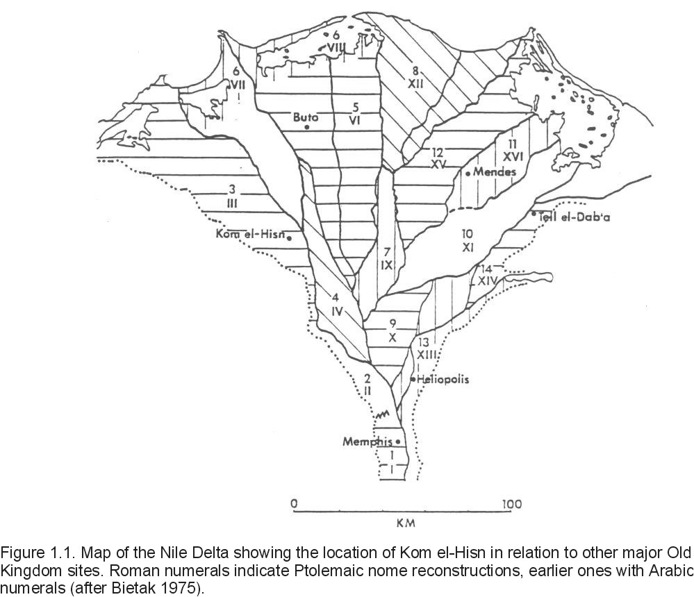
Kom el-Hisn itself is located near the western edge of the Nile delta approximately midway between Cairo and Alexandria and about 13 km west of the Rosetta branch of the Nile (Figure 1.1). The extinct Canopic branch of the Nile may have been even closer to Kom el-Hisn during its occupation. The site is surrounded by cultivated land and a village has been built on a portion of the site at its southwestern extent. It is composed of primarily Old Kingdom deposits containing substantial domestic architecture along with abundant ceramic, floral and faunal remains (Moens and Wetterstrom 1988, Wenke and Redding 1985, 1986, Wenke et al. 1988a). The occupational deposits are up to 3 meters thick and rest upon a topographic saddle composed of Pleistocene sands and gravels known in Arabic as gezira. From textual sources Kom el-Hisn is known since the 5th Dynasty as imAw ("Yamu"). It is located in the 3rd Nome of Lower Egypt in which some texts have placed the so-called Estate of the Cattle, though the exact location of this estate is not known. Middle Kingdom descriptions of Kom el-Hisn do, however, indicate Hathor as the principle deity of the city and the remains of a temple to Hathor have been found on the site.
Radiocarbon dates, together with epigraphic finds and artifact styles, indicate that Kom el-Hisn was occupied during Dynasties V and VI (ca. 2500-2290 B.C.) and into the Middle Kingdom (ca. 1890 B.C.; Wenke, et al. 1988a). There are also extensive New Kingdom cemeteries in the northern portion of the site, and it has been suggested that some First Intermediate burials are included within the Old Kingdom architecture (Wenke et al. 1988a). Kom el-Hisn was thus occupied during the height of Old Kingdom power and to some extent during the upheavals of the First Intermediate period and the reorganization of the Middle Kingdom.
Before the current research was undertaken only sporadic work had been done at Kom el-Hisn, little of it relating to the Old Kingdom remains. Except for a few minor visits to the site in the late 19th and early 20th centuries (e.g., Petrie 1886; Junker 1928) the only other large-scale excavations were conducted by Hamada and el-Amir (1947) and Hamada and Farid (1947, 1948, 1950) on the primarily New Kingdom and First Intermediate period cemeteries to the north of the site. Hence, until now little apart from epigraphic references was known about Kom el-Hisn.
Previous analyses of some of the material excavated at Kom el-Hisn (principally from the 1984 and 1986 seasons) have tended to support the notion that Kom el-Hisn was at least in part specialized for cattle production. Many of the plant remains recovered come from plants commonly used as animal fodder, together with a lack of cattle bones in the samples analyzed thus far, indicate that cattle production was geared mostly towards export and not local consumption (Moens and Wetterstrom 1988; Wenke et al. 1988a, Redding 1992, ND). Other faunal remains of domestic animals indicate a typical Egyptian diet of pigs and sheep/goat. The age distributions of the samples analyzed thus far indicate a common practice of slaughtering primarily younger animals and older non-milk producing animals. Various fish and fowl were also common, many species of which were available locally. However, one marine species of fish, Sparus auratus, seems to have been transported to the site after initial processing (decapitation and possibly drying), presumably from the Mediterranean coast (Redding ND:9).
Most of the ceramics can be identified with typical Egyptian Old Kingdom and Middle Kingdom wares and represent mainly food storage, preparation, and consumption forms; only a small fraction are of decidedly non-local (Lower Egyptian) origin (Wenke et al. 1988a). It is unclear whether the former were manufactured on-site or imported from some distance, since no evidence of ceramic production (kilns, slag, etc.) have been found. However, if such production areas were separated from the main occupation areas they are unlikely to have been found given the sampling methodology.
Thus, Kom el-Hisn represents one of a very few systematically excavated settlement sites in the Delta region with a statistically valid sample of artifactual remains. The overarching problem addressed by this study is how to describe the functional complexity of the site in terms that can be explained by theory and which is also applicable to other sites of varying complexity. I will accomplish this by focussing on two methodological issues crucial for maintaining control over the significance of spatial and temporal patterns. First, the basic units of analysis, artifacts, or in this case artifact types, will be examined for their functional relevance or how well they accord with a theoretically-derived definition of function. Once the bridging arguments between artifact type and functional relevance have been made, the distributions of these artifact types over space and their co-occurrence with other artifact types can be assumed to reflect loci of activities. In part, this is an inductive exercise, since the functional relevance of the resulting types is being tested empirically.
Second, I have paid particular attention to the aggregation units that define the distributions: the deposits in which the artifacts occur. Traditionally, the definition of what constitutes a deposit has been treated rather cursorily during excavation. The excavator provides an interpretation of what a particular stratum represents (e.g., house floor, dump), usually by implicit criteria learned through experience. I have systematized deposit definitions based on strictly geological principles of sediment transport and deposition. The current positions of all artifacts in any site are a product of the last depositional event that moved and deposited them and any post-depositional processes that acted upon them. Consequently, the spatial locus of the artifacts contained therein is a function of depositional processes that acted on all of the included artifacts rather than the inferred histories of individual artifacts. By controlling for the variation due to common depositional processes, other sources of variation can be explained by processes other than depositional ones.
The resulting depositional unit (DU), is defined as a set of particles, including artifacts, that came together by the same set of depositional processes. All DU's of a certain type are assumed to have similar depositional processes. Therefore, the DU is the basic unit that determines how different classes of artifacts are distributed across space and how they are associated with each other via frequencies. Variation within a given type of deposit can be expected to result from some factor other than the depositional process itself; for example, different sets of activities. If the artifacts contained therein can be shown to have functional significance, then that variation is assumed to be functional in nature, once random processes have been accounted for.
In Chapter 2 I review the development of Egyptian settlement patterns and settlement structure to provide the context in which the Old Kingdom pattern developed. These preexisting settlement patterns are especially important when the unification process is examined because of the ways a change in the administrative hierarchy may affect the function of preexisting settlements and the placement and functions of new ones. This chapter also provides a more detailed discussion of the previous work conducted at Kom el-Hisn and hypotheses regarding its position in the socio-economic structure of the later Old Kingdom.
Chapter 3 provides the theoretical and methodological justification for the creation of analytic units employed in later analyses. This chapter covers not only the specific issues relating to the current research but also outlines some of the explanations offered by other researchers for the development of Egypt's particular brand of complex society.
Chapter 4 describes the research program that provided the data on which this study relies. It also presents the specifics of how deposit types were derived and the results of testing the resulting deposit classification to ensure that the deposit types reflect analytically useful units. This chapter also analyzes the depositional history of the site and establishes appropriate chronological controls so that temporal and spatial variation can be differentiated.
Chapter 5 contains detailed descriptions of the deposits associated with each excavation unit in the analysis. Each DU in the unit's stratigraphy is described for its overall sedimentary character, particle content, artifact abundance, relation to other deposits in the sequence, and occupation level assignment. At the end of each set of DU descriptions a summary of the depositional history of the excavation unit is provided.
Chapters 6 and 7 contain the statistical analyses that build the model of functional differentiation found within the excavated areas. Chapter 6 discusses the four main types of artifactual data in turn (ceramics, faunal remains, stone tools, and plant remains), the classes used in the analysis, their relevance to an analysis of functional variation, and the distribution of individual artifact types among deposit types. Chapter 7 then examines the spatial distribution of artifact types. The main tool in these analyses is cluster analysis, used to group units with similar distributions of artifacts. The resulting clusters are then analyzed further to determine which artifact types are controlling the clustering routine and the functions that these types represent. Types that vary with other functional data, such as particular types of faunal remains or architectural features, represent loci of activity within specific structures. The result is a map of the site designating discrete functions or sets of functions associated with architectural features.
The final chapter (8) summarizes the results of all analyses and describes the functional layout of Kom el-Hisn. Here, I compare the structure of Kom el-Hisn with other settlement sites in both Old and Middle Kingdom Egypt. This places Kom el-Hisn within the larger context of the Egyptian state structure and allows some conclusions to be drawn as to how Kom el-Hisn functioned within this structure.